Wuhan, China
 CHINA – WUHAN 2002. | |
| V prvom rade by som sa chcel poďakovať za túto jedinečnú možnosť Milanovi Frajtovi a Prof.Vladovi Sedlákovi, ktorí mi umožnili v rámci ich katedry (ako participant riešenia úlohy Deformation monitoring and modelling geotectonic recent movements and landslides in GIS in the Slovak Republic and the People Republic China from the point of view of the environment protection) cestovať a zúčastniť sa tak cesty do krajiny, o ktorej som mohol maximálne pozerať dokumentárne filmy a internetové stránky. Navštívili sme Wuhan, Peking, Čínsky múr, Three Georges, Nebeské námestie, Zakázané mesto a mnoho iného. ==>Fotogaléria z výletu. | |
 Beijing Town Beijing TownPeople’s republic of China capital city – King Wu was the first to declare Beijing the capital city in 1057 BC. Subsequently, the city has gone by the names of Ji, Zhongdu, Dadu, and finally Beijing when the Ming Dynasty Emperor ChengZu chose the name in 1421. Beijing was also known as Peking by the Western world before 1949. Beijing City is an independently administered municipal district. She is situated in the northeastern part of China at an elevation of 43.5m above sea level. The climate in Beijing is of the continental type, with cold and dry winters and hot summers. January is the coldest month (-4 Celsius), while July the warmest (26 Celsius). | |
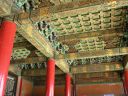 Beijing – Forbidden City Beijing – Forbidden CityA Tang Dynasty poet wrote a line about the royal palace of his time, which says „Without seeing the magnificence of the royal palace, one can never sense the dignity of the emperor.“Magnificent and awe-inspiring, that is how every visitor would describe the Forbidden City, which served as the seat of imperial power during the Ming and Qing dynasties (1368-1911). | |
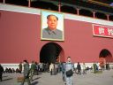 Beijing – Tian-an-men Square Beijing – Tian-an-men SquareThe Tiananmen Square in the center of Beijing, is said to be the biggest square in the world. It is 880 meters from north to south, and 500 meters from east to west, with total area of 440,000 square meters and can hold one million people. The Tiananmen Gate Tower sites at the north, the Five-Star Red Flag flies high on the square, the Monument to the People’s Heroes dominates the center, the Great Hall of the People and the Museum of the Chinese Revolution and the Museum of Chinese History to the east and west of it, as well as The Chairman Mao Memorial Hall and the Qianmen gate, sit in the south of the square. Over several hundred years, in front of the Tiananmen, many democracy meetings and demonstrations are held. Tens of thousands of people visit daily. The Square is listed top among Beijing’s 16 scenic spots. | |
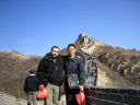 Great Wall Great WallTo the northwest and north of Beijing, a huge, serrated wall zigzags it’s way to the east and west along the undulating mountains. This is the Great Wall, which is said to be visible from the moon. Construction of the Great Wall started in the 7th century B.C. The vassal states under the Zhou Dynasty in the northern parts of the country each built their own walls for defence purposes. After the state of Qin unified China in 221 B.C., it joined the walls to hold off the invaders from the Xiongnu tribes in the north and extended them to more than 10,000 li or 5,000 kilometers. This is the origin of the name Of the „10,000-li Great Wall“. | |
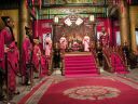 Ming Dynasty palace Ming Dynasty palaceThe Ming dynasty began in 1368, and lasted until 1644 A.D. Its founder was a peasant, the third of only three peasants ever to become an emperor in China. He is known as Hongwu Emperor, and led the revolt against the Mongols and the Yuan Dynasty. He was constantly worried about conspiracies against himself, and despite the many moral homilies he gave, favored violence in dealing with any one suspected of plotting against him or associated with the conspirators. The capital was originally located in Nanjing but the third emperor moved the capital to Beijing. | |
 Three Georges Three GeorgesThe world biggest dam. Location: Sandouping, Yichang, Hubei province, Height: 181 meters, Expected investment: 203.9 billion renminbi (US$24.65 billion), Number of migrants: 1.13 million, Installed power generation capacity: 18.2 million kilowatts, Functions: Flood control, power generation, improved navigation. | |
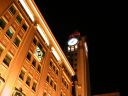
 Wuhan WuhanWuhan is described as the „Homeland of White Clouds and green Crane“ The Yangtze River and the Han River join here,dividing the city into three towns:Hankou, Hanyang and Wuchang. Wuhan has many scenic spots and historical sites. Among them are the 2,400 years old Zenghouyi Chime Bells known as one of the world wonders; the 1,700 yearsold green Crane Tower, one of the three famous towers in South China: the East Lake whose natural beauty rivals that of the West Lake in Hangzhou;the TY Tower on Tortois Hill known as the highest mast of Asia; the ancient Guiyuan Temple, and the modern International Amusement Park. | |
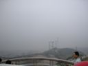
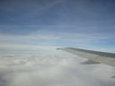 Flight photos Flight photosSome photos from aircraft. | |
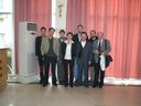
 Travelling TravellingPhotos from travelling in China. | |
| Where is Wuhan on the World map? (powered by google.com) Go to Wuhan City by Google Maps Download here Google Earth KMZ file Here are some stories about our travel (Mef) : And here are some links relevant to our travel : The Forbidden City Wuhan Other links | |
Prvý komentár